***ALL TREKS REQUIRE AN RSVP: CLICK HERE FOR ONLINE RSVP LINK.***
TRAIL RATING: All of these trails are rated moderate (may have some short inclines meaning there may be a strenuous portion for a short amount of time).
NOTE: all of these hikes will have an option for families who want to go a shorter distance and an option for those who want to complete a longer (4+ miles) round trip hike.
WHAT TO BRING ON ALL HIKES: sunscreen, hat, daypack, lots of water (bottles or hydration pack), snack or lunch, camera, first-aid kit, good shoes (sandals are not recommended), layers and/or light jacket.
**UNLESS OTHERWISE NOTED MEET-UP TIME FOR ALL HIKES IS 12 Noon EST**
UPCOMING TREKS - WINTER 2014
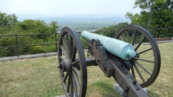
Jan. 18: Urban Hike - Missionary Ridge
Meet at NOON at the Bragg Reservation monument area on Missionary Ridge (easiest way to get there is take Main Street to the top of the ridge, turn right on S. Seminole then immediately right on Sheridan and continue up to the monument parking area).
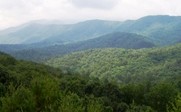
5 mile hike roundtrip The historic Missionary Ridge community is located approximately three miles east of downtown Chattanooga, TN and rises nearly 500 feet above the valley and separates downtown from the suburbs. It is part of the Cumberland Range of the Southern Appalachians and is an excellent vantage point for views of Lookout, Signal and Raccoon Mountains. It is a major geographic feature in Chattanooga, Tennessee and was the site of the Battle of Missionary Ridge, a significant battle in the American Civil War. The Ridge today is an affluent residential area with many plaques and monuments to the battle, some of which are in the yards of residents, but most of the larger ones are surrounded by small reservations which are part of Chickamauga and Chattanooga National Military Park. Crest Road follows the summit of the ridge for nearly its entire length bisected only by quiet side-streets and cul-de-sacs along the way. http://www.civilwar.org/battlefields/chattanooga/chattanooga-history-articles/chattanooga-lookout.html Feb. 8: Buggy Top Trail and Sewanee Natural Bridge (Monteagle)
Meet in the parking lot of the Hardees at the Browns Ferry Exit off I-24 East (those who want to carpool from here can).
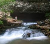
2.2 miles one way; rated moderate. Sewanee Natural Bridge State Natural Area includes a sandstone arch that is 27 feet high and spans 57 feet. The Buggytop Trail leads to the area's big feature Lost Cove Cave, its entrance described in Thomas Barr's Caves of Tennessee: "[It is] one of the most impressive cave mouths in the state. It is 100 feet wide and 80 feet high and opens at the base of an overhanging bluff 150 feet high. The cave stream cascades down from the mouth and drops 40 feet in less than 100 yards." Mar. 8: South Chickamauga Greenway (Sterchi Farm Segment)
Meet at NOON at the Sterchi Farm Park Trailhead. DIRECTIONS: From Amnicola Hwy. east, going away from downtown Chattanooga, turn right on Access Rd., the traffic light immediately west of the Hwy. 153 interchange. Take the next right onto Old Harrison Pike. After approx. one mile, Old Harrison Pike will turn 90 degrees left to cross S. Chickamauga Creek. Sterchi Farm Park is immediately on the left after crossing the creek. No rest rooms.
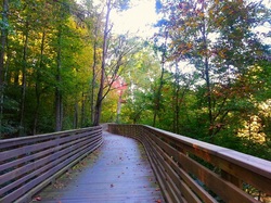
The South Chickamauga Creek Greenway is a paved and gravel, multi use trail and boardwalk that runs parallel to the creek through the middle of metropolitan Chattanooga. The newest Sterchi Farm Park section is paved and features boardwalks that tower as much as 30 feet above the creek, towering oak, hickory forests and rolling farmland. The trail crosses under city streets and active railroads, and crosses the creek at Bonny Oaks Dr. http://www.outdoorchattanooga.com/199.htm |
PAST TREKS
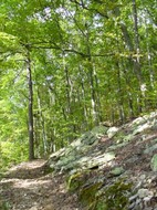
Nov. 23: Lookout Mountain - Guild Trail
Meet at NOON at the trailhead just outside the Ruby Falls parking lot on Lookout Mtn - drive behind the Ruby Falls Visitor's Center to the far parking lot - tell the attendant you are going to hike the trail.
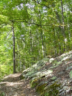
3-4 miles The Lookout Mountain Guild-Hardy Trail is a walking and biking trail located on the side of scenic Lookout Mountain rated easy to moderate. The trail was built on the historic route of the C & LM Broad Gauge Railroad and follows its path up the mountain. Two remaining trestles are the most captivating evidence of the railroad. The Guild-Hardy Trail provides walkers and cyclists access to a multitude of trails on Lookout Mountain, National Park Service and Reflection Riding. The GH Trail winds through forested mountain slopes littered with historical ruins, by Ruby Falls and the Cravens House. http://www.lib.utexas.edu/maps/national_parks/chickamauga_lookoutmt99.pdf Oct. 19: Pinhoti Trail (Snake Creek Gap) North GA
4-6 miles.
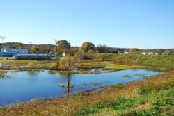
Meet up at NOON in the Kmart parking lot in Ft. Oglethorpe on the end near the Blockbuster store. The Pinhoti (Creek for the turkey's home) Trail is one of the Southern Appalachian Mountain's premier long distance hiking trails, offering over 160 miles of recreation opportunities for hikers, backpackers, horse-riders, and mountain bikers in the state of Georgia. It also serves as an excellent connector trail, linking the Pinhoti Trail in Alabama to the Appalchian Trail atop Springer Mountain, via the Benton MacKaye Trail found on the South Fork of Jacks River within the Conasauga Ranger District. http://www.atlantatrails.com/hiking-trails/pinhoti-trail-hiking-north-from-snake-creek-gap/ April 20: Brainerd Levee / Wetlands Area Urban Trek
3-5 miles
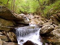
Meet in the parking lot of the Shallowford Road entrance at NOON; 4-6 miles. This is a GREAT hike for families and kids as the levee is flat and wide and easy to walk on. The Brainerd levee and retention area were built in the 1970's to prevent flood waters from South Chickamauga Creek from damaging the neighborhoods in Brainerd. This stormwater control structure has created a freshwater marsh and seasonal mudflats. Habitats include a cattail marsh, seasonal mudflats, wet fields, wet woods, shallow ponds, fields with shrub and shrubby edges, and riparian woods. http://www.outdoorchattanooga.com/199.htm Mar. 2: Rock Creek Gorge Waterfalls (Ocoee River Zone)
4-6 miles
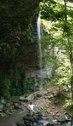
Meet in the parking lot of the Publix at the Ooltewah exit at NOON; we will carpool from here. This trail is located in the Cherokee National Forest in the Ocoee River Zone. This area is known for it's scenic waterfalls - there are a couple of shallow creeks to cross on the hike - this time of year the water should be low enough to rock hop across. Bring extra shoes/dry socks just in case. This is a nice easy hike for families with kids, beginners, or anyone wanting to enjoy an afternoon in the woods! http://www.fs.usda.gov/recarea/cherokee/recreation/hiking/recarea/?recid=35112&actid=50 Feb. 9th: Indian Rock House/Snooper's Rock (Cumberland Trail)
Meet in the parking lot of the Signal Mountain Bi-Lo at NOON; we will carpool from here.
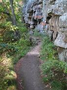
This part of the Cumberland Trail is about 35 minutes outside of Chattanooga on Suck Creek Mountain in the Prentice Cooper State Forest. Once you enter the forest area there is only gravel road to the parking location. Bring a snack and enjoy an afternoon here - one of the best hikes in the his area. Roundtrip is 6 miles to Snooper's Rock and back. URL: http://www.cumberlandtrail.org/rivergorge.html Jan. 19: Urban Hike on Historical Missionary Ridge

Meet at the Bragg Reservation monument area on Missionary Ridge (easiest way to get there is take Main Street to the top of the ridge, turn right on S. Seminole then immediately right on Sheridan and continue up to the monument parking area).
2-5 miles The historic Missionary Ridge community is located approximately three miles east of downtown Chattanooga, TN and rises nearly 500 feet above the valley and separates downtown from the suburbs. It is part of the Cumberland Range of the Southern Appalachians and is an excellent vantage point for views of Lookout, Signal and Raccoon Mountains. It is a major geographic feature in Chattanooga, Tennessee and was the site of the Battle of Missionary Ridge, a significant battle in the American Civil War. The Ridge today is an affluent residential area with many plaques and monuments to the battle, some of which are in the yards of residents, but most of the larger ones are surrounded by small reservations which are part of Chickamauga and Chattanooga National Military Park. Crest Road follows the summit of the ridge for nearly its entire length bisected only by quiet side-streets and cul-de-sacs along the way. The only Frank Lloyd Wright home in Tennessee if located here. http://www.civilwar.org/battlefields/chattanooga/chattanooga-history-articles/chattanooga-lookout.html Jacks River Trail (Cohutta Wilderness)
Meet at NOON in the parking lot of the Burger King at the Ooltewah Exit off I-24 (those who want to carpool from here can). 2-4 miles
This moderately difficult, orange-blazed trail is the roadbed of an old railroad. It is the longest and wettest trail in the Cohutta Wilderness - we will hike 2-4 miles. THERE ARE MULTIPLE WATER CROSSINGS - BRING WALKING STICKS/POLES IF YOU HAVE THEM! You must be prepared to get wet on this trek. Bring a change of clothes - if you have water shoes those are recommended. Buggy Top Trail and Sewanee Natural Bridge (Monteagle, TN)
Meet in the parking lot of the Hardees at the Browns Ferry Exit off I-24 East (those who want to carpool from here can).
2.2 miles one way; rated moderate. NOTE: if there are enough interested folks, we'll do a longer trek after we see the cave! Sewanee Natural Bridge State Natural Area includes a sandstone arch that is 27 feet high and spans 57 feet. The Buggytop Trail leads to the area's big feature Lost Cove Cave, its entrance described in Thomas Barr's Caves of Tennessee: "[It is] one of the most impressive cave mouths in the state. It is 100 feet wide and 80 feet high and opens at the base of an overhanging bluff 150 feet high. The cave stream cascades down from the mouth and drops 40 feet in less than 100 yards." Lookout Mountain Bluff Trail (Covenant College to Sunset Rock)
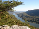
We'll meet up in the St. Elmo Bi-Lo parking lot at 1pm EST. One of the area's nicest hikes with great views into Chattanooga valley and downtown Chattanooga. We'll meet up in the St. Elmo Bi-Lo parking lot - this will be a shuttle hike so we'll need to park at least 2 cars in the Sunset Rock parking lot before going back to the trailhead by Covenant College. Hike is easy- moderate and 4 miles with lots of wonderful views. One of the area's nicest hikes with great views into Chattanooga valley and downtown Chattanooga.
Coker Creek Trail (Tellico Plains)
NOTE: the meetup time for this trek is NOON due to the longer driving time to the trailhead. MEET-UP LOCATION IS THE OOLTEWAH EXIT CRACKER BARREL PARKING LOT AT NOON. Trail is 2.0 to 8.0 miles; rated moderate-strenuous; please bring an adequate lunch (not just snacks).
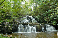
Coker Creek Scenic Area (375 acres) is a small part of the Coker Creek valley, but it offers outstanding features including Coker Creek Falls; thick, lush forests of deciduous and evergreen trees with some old-growth hemlocks and white pine; wildflowers - Coker Creek flows into the Hiwassee River. The community of Ironsburg near the headwaters of Coker Creek got its name from an ironworks built by the Cherokee before 1812. Carroll Ironworks later bought it from the Indians, and in the winter of 1863 General Sherman destroyed it. Coker Creek was the site of a gold strike. When the discovery was made in 1820s, about the same time gold was found in northeast Georgia and more than two decades before the California strike, Coker Creek became a bustling place. http://hiking.chattanooga.net/cnfcoker.htm Keown Falls Scenic Area (Rocky Face, GA)
Meet in the parking lot of the GA Welcome Center off I-75 South (those who want to carpool from here can).
1.8 to 5.0 miles; rated moderate. One of the nicest spring hikes in the area! This scenic area was set aside because of the unique rock bluffs and high elevation swampy areas formed from springs. Keown Falls, named for land surveyor Gordon Keown, are twin falls located along two spring-fed streams within the 218-acre scenic area. The larger one free-falls 60 feet and the smaller about 40 feet. URL: http://www.southernhiker.com/keownfalls-2/ Savage Gulf State Park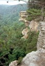
Meet at Hardees at the Browns Ferry Exit on I-24. **NOTE: it is about 1 and a half hour drive to the trailhead so meet-up is 11am EST.**
2.0 to 8.0 miles; rated moderate-strenuous. The Collins Gulf Trail and the Stagecoach Road Historic Trail combine with short connector trails to make one of the most fascinating loop hikes in the South Cumberland. One of the trip highlights is a visit to the massive rock wall arena of the Suter Falls gorge. The Stagecoach Road Historic Trail follows the old route of the Stagecoach toll road that ran from McMinnville to Chattanooga. This old roadbed with its rock walls and stone cribbing built using slave labor, is on the National Register of Historic Places. Carved like a giant crow foot into the western edge of the Cumberland Plateau, the Savage Gulf State Natural Area is one of Tennessee’s most scenic state outdoor recreation areas. At a length of five miles each, the Big Creek, Collins River and Savage Creeks tumble down over 800 feet in elevation through narrow gorges, locally known as "Gulfs." Rimmed by sheer sandstone cliffs, the rugged canyons offer the hardy visitor a fine glimpse of the true wilderness still remaining in our State’s midsection. The Stone Door was used for centuries by the Indians as a passage way from the top of the escarpment into the gorges below. |
